
A Visual Query and Analysis System for Mission Specific Visualization
The system in this project provides GIS (Geospatial Information System) data analysts with an effective way to visualize multidimensional data and visually filter information from it. In GISs, most of data are in conjunction with location information and shown to data analysts on top of the location layer such as a map. For this reason, it is necessary to help them minimize distraction from their track on the spatially distributed data and at the same time handle database intuitively.
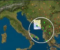
With the system we proposed in this project, avoidingcomplex database schema, the analysts are able to build idea towards the final decision through the repeated interaction with data. Using this system, extended idea of Magic LensTM interface, we made the way that data analysts bring the movable visualization interface to the data as opposed to the way that they repeatedly load the data to visualization tool and analyze the data individually. This system thus allows data analysts to effectively keep their hypotheses in mind while they are applying their hypotheses to the data. Taking advantage of it, they can reach the higher knowledge level and ultimately final decision.
Participants: Sang-Joon Lee, James K. Hahn